What Lock 23 Looks (Looked) Like - Incl. Divers Views
Lock 23 & the Rapide Plat Canal Before the Seaway
Thanks to Ron Beaupre for these historic pictures from his collection - to see more CLICK HERE.

SHWC028: Tanker EASTERN SHELL heading up the canal. The buildings to the left of the Shell tanker EASTERN SHELL are the Government Shipyard. It was located just west of Steward’s Creek.

SHWC027: Rapide Plat Canal West of Morrisburg. RAPIDE PLAT CANAL - Morrisburg, Ont. - Looking down the canal from a point 1 mile above Lock 23. 1954.

SHWC024: Canallers waiting above Lock 23 for their turn to use the lock. This view shows steamers above Lock 23. Steamer "James Stewart" is in the foreground. When water levels in the Rapide Plat were too low to risk fully loaded down bound canallers shooting the rapids, they would use the canal to bypass the rapid. The choice of whether or not to shoot the rapids was up to the captain, and he would be checking water level gauges before attempting it.

SHWC023: CITY OF WINDSOR departing Lock 23. The package freighters built for CSL were slightly narrower than most canallers. Therefore they moved more quickly into and out of the locks. They were also given priority over bulk freighters for the turn at getting the lock.

SHWC022: Saltwater ship entering Lock 23. British steamer CORALSTONE upbound in Lock 23. The British flag CORALSTONE sailed into the Great Lakes 1927-’29 and 1933.

SHWC020: Looking down through Lock 23.

SHWC019: New Lock 23 at Morrisburg. The canaller JAMES STEWART approaching Lock 23 from the river. The Morrisburg Hydro-Electric plant is on the left.

SHWC018: Looking down the canal at the Morrisburg Locks. From the left we see the Morrisburg Hydro Electric plant and power canal leading down to it, old Lock 23 with the gatelifter secured below it, new Lock 23 with steamer TOILER, loaded with pulpwood, exiting the lock up bound. Date of photo about 1919.

SHWC017a: Flower Beds at the west end of Lock 23. The men who worked at the lock took great pride in the appearance of their facility.

SHWC016: Morrisburg Canals Morrisburg Locks and park at the foot of Lock Street, prior to the Seaway flooding.

SHWC014: Wooden ships on the pier below Morrisburg’s Lock 23. This view below Lock 23 at Morrisburg shows the tug Fredmac and two barges upbound and the steamer Mapleglen downbound.

SHWC011: Lock 23 at Morrisburg from the river This photo shows the lower gates of the Morrisburg Locks as seen from a steamer passing down the river in July 1939. Photo by Ivan Brookes.
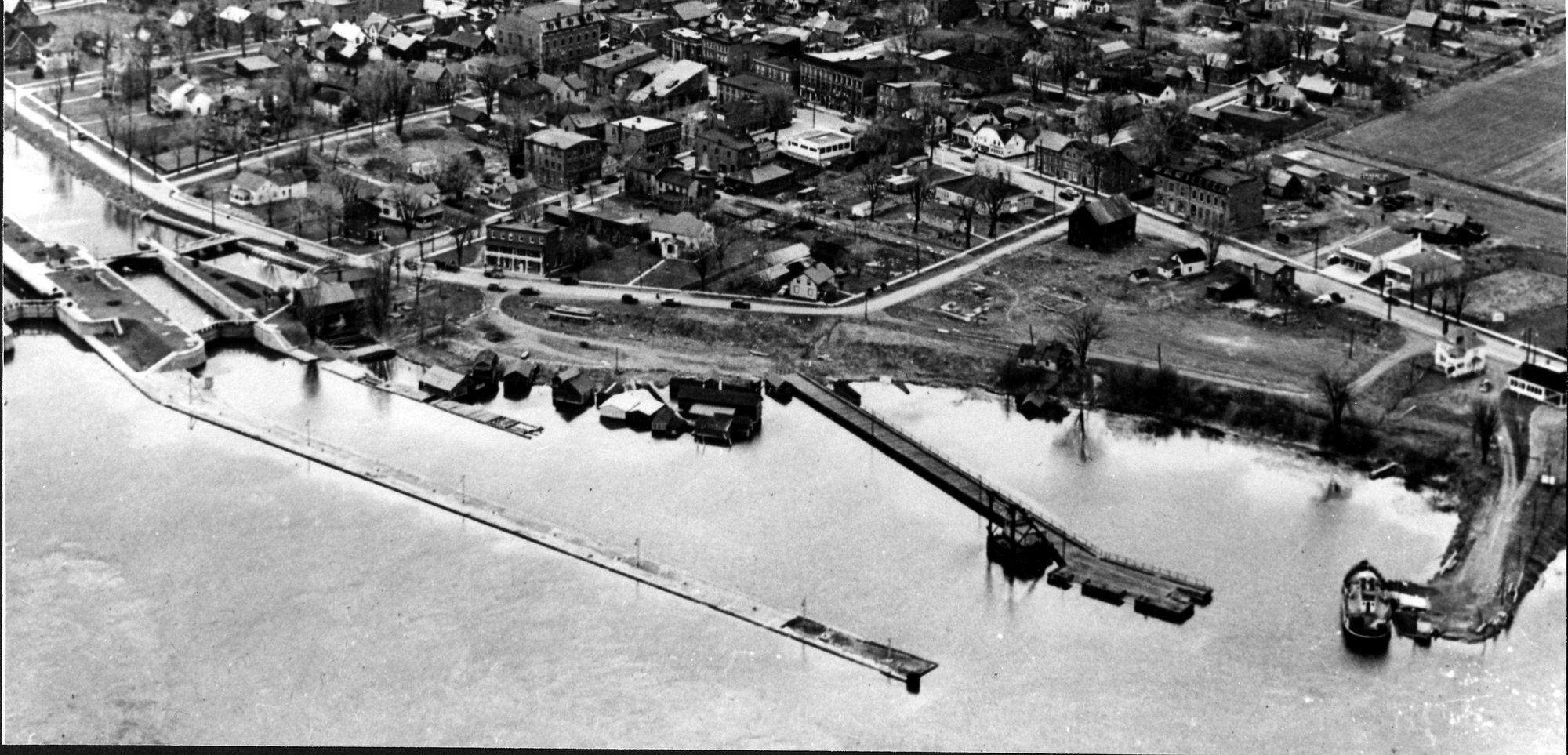
SHWC009: Morrisburg Harbour and Canal. From left to right in this aerial view we see the entrance to the Rapide Plat canal with the first lock that was completed and opened in September 1847. The channel immediately to the right of the lock is to supply water to the hydro electric plant. The long pier in the foreground is the approach to the larger lock completed in 1904. Next down the shore is the Municipal Wharf where a gate lifter is secured. To the left of this wharf is the landing for the Morrisburg ferry to Waddington N.Y. The area of the village of Morrisburg seen here was totally obliterated because of the advent of the Seaway.

SHWC008a: Aerial view of St. Lawrence River from Morrisburg to west of Mariatown. The entrance to the Rapide Plat or Morrisburg Canal can be seen at the top right hand corner. The Morrisburg Ferry dock is due south of Lock 23 and is located on Dry Island. To the lower left is a bridge across “The Little River” which is in reality a shallow part of the St. Lawrence which ran south of Ogden Island. Farms, now gone, can be seen on Ogden Island. The two islands to the right of center are Canada to the north and Clark to the south. The main Seaway shipping channel now runs between Ogden and Canada Islands. Clark Island has disappeared beneath the waters.
Divers Views
To get a detailed perpective of diving at Morrisburg's Lock 23 see Sydney Schnurr's website at https://morrisburgdivesites.com/
The following nine pictures give some excellent views of what the Lock 23 Diving Enthusiasts see. A big thank you to Sylvain Marcotte, a Lock 23 Diver from Montreal, who kindly gave us permission to use these pics. He retains ownership of all copyright rights.
.jpg)
.jpg)
.jpg)
.jpg)
.jpg)
.jpg)
.jpg)
.jpg)
.jpg)
These pictures are provided by Christian Rémillard.
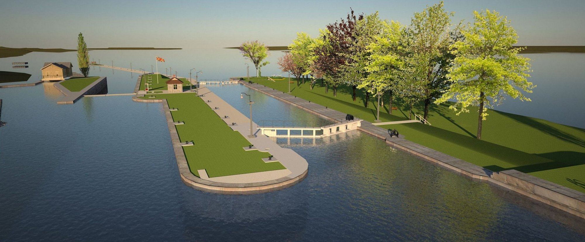
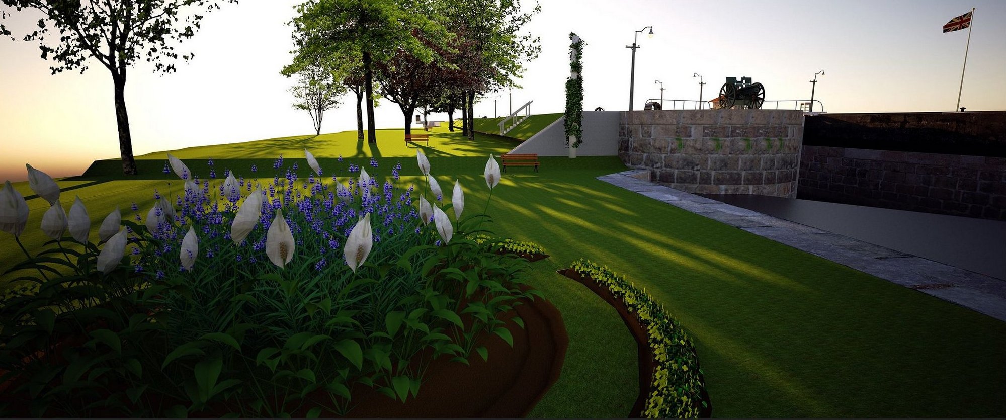
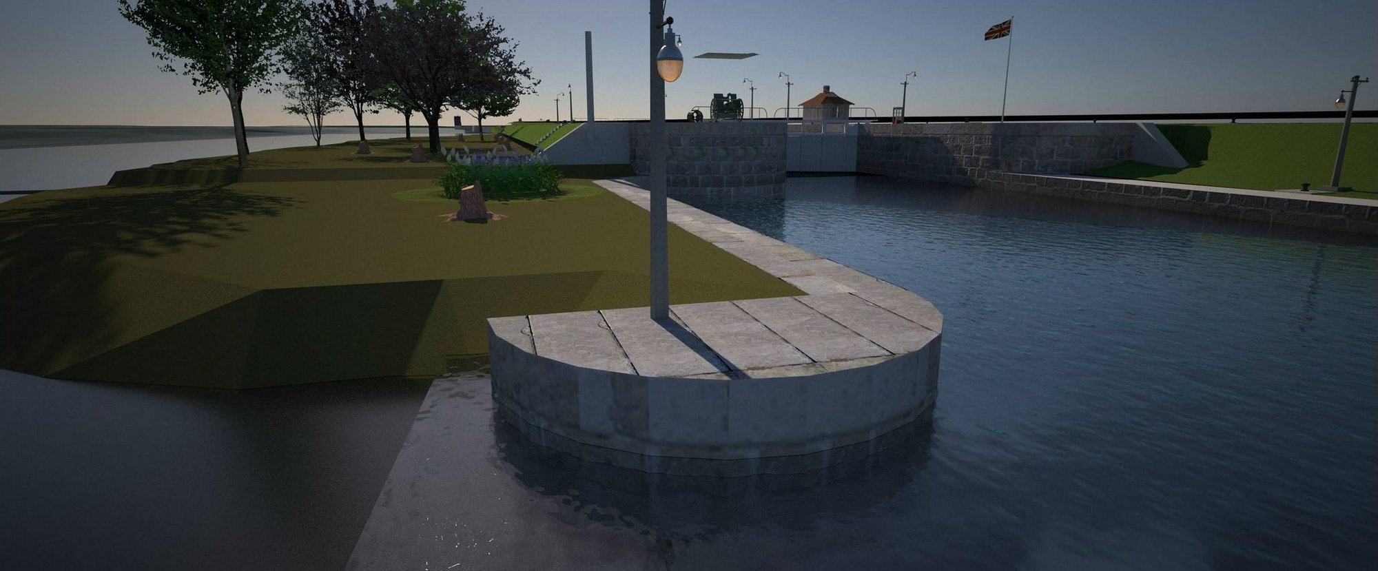
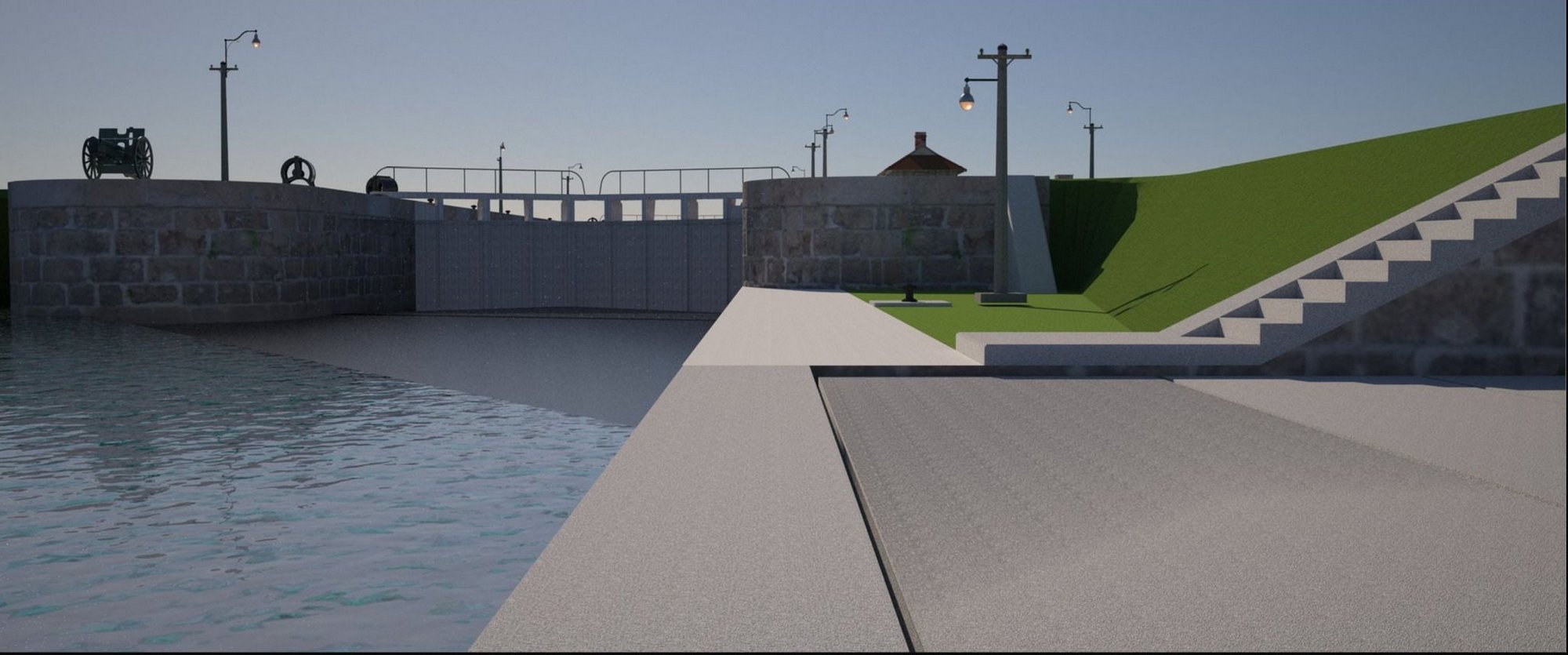
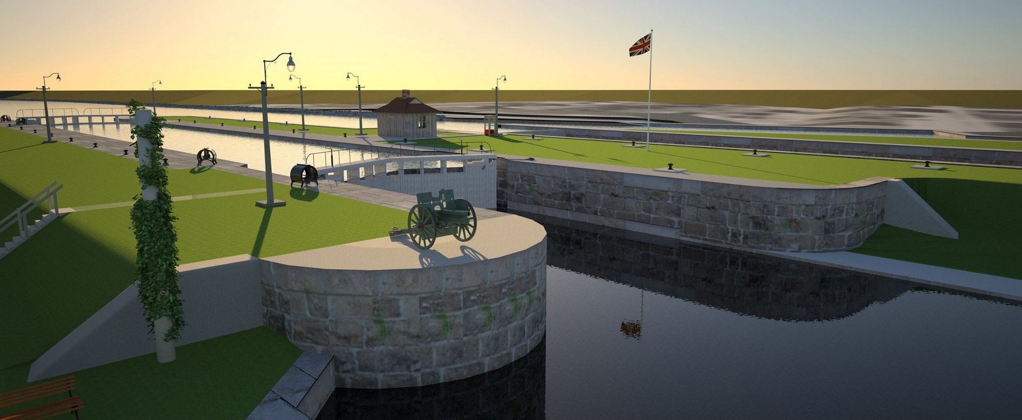
Christian is a webmaster at the University of Montreal and an avid and experienced diver. He has been diving at Lock 23 in Morrisburg for 10 years and it is one of his favourite diving locations. The following pictures are from a 3D model he created from numerous dives he did to get measurements of the actual Lock 23 as part of an effort to reconstruct the site as it looked like before the St Lawrence Seaway construction and flooding in 1958. He owns the copyright for all the pictures and we reproduce them with his permission.